 |
| My route |
January 5-6, 2017:
In 1540, Don Francisco Vasquez de Coronado led a large expedition (an army) north from Mexico into what is now the United States. Some scholars believe they crossed the border along the San Pedro River and worked their way northward to the Zuni Pueblos of New Mexico – near present-day Gallup. They went on from there into what is now Kansas, before returning to Mexico. Along the way they "discovered" the Grand Canyon, much to the surprise of the local inhabitants who had been hoping they'd all fall into it.
One of the routes that is possible (for the Arizona part of their passage) is between Safford, AZ and Springerville, AZ, along the spiny and rugged backbone of far-eastern Arizona. I am not so sure; in fact, I really doubt it. While Coronado didn’t have much information about what was in front of him, if he DID take that particular route, it wouldn’t have been possible to find a more difficult one for an army on foot and horseback and driving other livestock along with them. That journey would have been from desert level up and across extremely rugged mountains that reach almost 10,000 feet MSL (an elevation gain of almost 3,000 meters).
If Coronado scouted ahead (and why wouldn't he?), while there were no easy routes, there were a couple that would have been less difficult to the west and to the east (the valley route of US180 in New Mexico is one of the routes that would have been somewhat easier for Coronado to have traversed, had he reached it across the desert lands to the E-N-E from the area around Safford). At any rate, rightly or wrongly, those living in the southwest have always called the route traced today by US191 the “Coronado Trail.” It is the highway across Arizona’s roof. I demonstrated great bravery to drive it in mid-winter! This route was originally numbered as US666, but that designation was abandoned for the new number because of its Christian-satanic implications. Actually, I think that designation was rather appropriate, although I still find myself drawn to it every few years.
 |
| Twisty US191 |
 |
| Picket Post Mountain |
From
the greater Phoenix area, I drove US60 east toward Globe, AZ. The highway is a divided road, but not
controlled access like an interstate or a motorway. It skirts Arizona’s legendary Superstition
Mountains on the south, and starts uphill to higher, more mountainous country
as you leave the old mining town of Superior. Old west history is all around! Wyatt Earp’s common-law wife, Mattie Blaylock, ended her days near here
and is buried in an unknown grave in the old Pinal burying ground nearby. Pinal was a mining community just a couple of
miles from Superior (not the Pinal that exists today), and a lot more people lived out that way in those days than do now.
 |
| Queen Creek Tunnel |
The
highway starts up the mountain right at the eastern side of downtown Superior
and climbs very quickly from desert vegetation to scrub oak on top – at the top
of the immediate climb is the Queen Creek tunnel, which when constructed in
1952, made the drive to Miami/Globe much easier and more direct. It was always a landmark my sisters and I
looked forward to when going that direction on road trips - we were always excited about "the tunnel." Once through the tunnel, the road continues
to climb (if less-steeply) and wind its way through and across the Pinal
Mountains, through a small community named “Top of the World” (hardly, at only
4500 ft MSL). Top of the World
(originally Camp Pinal, later Pinal Ranch and Craig Ranch) was at various times an
Army post (for a short time, until General Crook abandoned it), a dance hall, a
ranch, and today is kind of a quirky community of about 200 souls on top of the
mountains. I’ve never stopped that
I can remember, but if you are into antiques, there is an antique store there unless things have changed. You can read an account of life at Pinal Ranch in the early part of this century written by Helen Baldock Craig, who moved there in 1928 as a new wife to a rancher. Among her stories is an account of how an Estey organ made its way from Boston to Globe - and then to the mountain top on a pack mule on trails "hardly wide enough for a horse and rider." Her story is called "Within Adobe Walls" (and was included in a book entitled Arizona Memories).
 |
| Pinto Creek Bridge |
Along
this very rugged stretch of the road (between Top of the World and Miami), the highway passes over Pinto Creek on a
steel arch bridge, high above the deep arroyo.
In 1962, some robbers did a bank job in Phoenix, and fled with a hostage
– a bank clerk named William Ward Clore Jr. who had dared to follow them. It made the newspapers for days – to my knowledge the robbers were never
caught so the crime was never solved.
Mr. Clore was never seen alive again and for years it was a mystery as
to what had become of him. In 1967, his
bones were found underneath the Pinto Creek Bridge. He had been murdered and tossed off the bridge
– or just tossed off the bridge. I
cannot pass over that bridge without thinking of him.
The
Miami/Claypool/Globe area is a pain to get through. It’s about ten miles of
road through these community’s business districts at 25-35 mph (ughh!). It seemingly takes forever, but relax and obey the speed limits – they do actively enforce them.
Anyway, if you haven’t been there before, there are some interesting things
to see and do. There’s the Besh-Be-Gowah
ruins (museum) for those interested in ancient cultures. Also, the old downtown areas (especially
Globe’s) are worth a look for the old business-district architecture.
 |
| Globe |
When
I was little, my Dad always took the US60 route out of Arizona and across New
Mexico (rather than US66 from Flagstaff and east).
Back in those days, the mines in Miami/Globe would dump the still-molten
by-products of their smelting operation down the sides of the slag heaps (which
you can still see above the town as you drive through – like hard-rock mesas). We’d always pass through late at night, and
if they were dumping a load of slag, it was a spectacular sight –
like volcanic lava flowing down a mountainside. They don’t do it that way anymore, I don’t
think.
On
the eastern side of Globe (finally), my route split off to the southeast
(US70) and the other highway (US60) turns off to the northeast toward the Salt
River Canyon, the White Mountains and Show Low.
I’m headed that way too – but by a much more circuitous route! US70 goes
out across the San Carlos Apache Reservation, not quite in a straight line, but
just curvy enough to keep your interest.
San Carlos was where they tried to put the Indians we generally (and
incorrectly) call Chiricahuas in the 1870s (along with some other Apachean
groups). But they were “mountain” people and they hated San Carlos - and they didn't like those other Apaches either. While the “Chiricahuas” soon fled (much to the Army’s
dismay), some of them ended up staying along with the others and it is a fairly vibrant
community today. I’ve always wanted to
attend the San Carlos rodeo at least once - one of the Arizona tribes' biggest economic drivers is ranching and livestock - so they are big with rodeo.
There are several communities along this stretch of road – San Carlos itself, Peridot, Bylas (named for an Apache leader), Geronimo, Ft Thomas, Pima, Thatcher and Safford. Most of these are Indian communities. There’s not much to do unless there is a rodeo going on – or some other community event perhaps. But along the way you’ll pass Geronimo, where that infamous hooligan was sent and told to farm along the Gila River. He didn't care much for farming, and he didn’t stay there long (the Indians considered the place to be pestilential) – but a spot on US70 near where he “homesteaded” for that short time is marked by an historical marker just to the east of the community that bears his name.
There are several communities along this stretch of road – San Carlos itself, Peridot, Bylas (named for an Apache leader), Geronimo, Ft Thomas, Pima, Thatcher and Safford. Most of these are Indian communities. There’s not much to do unless there is a rodeo going on – or some other community event perhaps. But along the way you’ll pass Geronimo, where that infamous hooligan was sent and told to farm along the Gila River. He didn't care much for farming, and he didn’t stay there long (the Indians considered the place to be pestilential) – but a spot on US70 near where he “homesteaded” for that short time is marked by an historical marker just to the east of the community that bears his name.
Arizona
road trips are often marked by mountains – our land is scattered with prominent
peaks from one end of the state to the other.
These marked the lives of the ancient peoples – and they mark our lives
today. The first one on this drive
stands just west of Superior – Picket Post Mountain – a mountain with a memorably
distinctive shape (I posted a photo above).
 |
| Mt Turnbull |
The
mountain was mentioned by travelers as early as 1846 – and had been given an
American name before these lands were ceded to the United States. It is a mystery how that happened. Some believe the mountain was named for
William Turnbull, a “distinguished topographical engineer” [Barnes, Will C. Arizona
Place Names. Univ of Arizona Press. 1988].
But if so, who named it? No one seems to know. Mt
Graham, nearby, was also given an American name during the Mexican-era. I have never heard (or read) that there were Spanish or Mexican names for either of them.
Speaking
of San Carlos Lake, it was formed by Coolidge Dam and has 158 miles of
shoreline. But how can they say that when there isn't any water in it? Shoreline bespeaks of water, doesn't it? For most of my life, that lake
has been mostly empty. It grows a beautiful crop of weeds and grass most of the time… Will Rogers once said of it, if it was his
lake, he’d mow it.
Somewhere along this stretch of the road, I once stopped at a roadside gas station (maybe at Bylas, or Geronimo, I don’t remember exactly). Of the things that ride was memorable for, two stand out in that area. I was on a motorcycle, on exactly the same route as this particular trip. I had left Phoenix wearing cut-offs, on a sunny summer day. I am extremely fair-skinned – but I was only going to wear the shorts long enough to get a little bit of a “tan.” Unfortunately, by the time I noticed it was time to don my blue jeans, it was way too late - the "slight pink" color soon gave way to "lobster red." That was the most memorable sunburn I ever had, and I burned through the skin to the muscle beneath. It was so bad, my doctor told me if I ever did it again, I could lose my legs. As it happened - I had to use crutches to walk for a couple of weeks. It made the remainder of that ride quite a misery.

The
other thing (much more pleasant), was at that little gas station where I
stopped; they still had a Coca-Cola vending machine that dispensed the little 8
oz glass bottles! They were about 25
cents each, icy cold, and I drank TWO of them.
Had I known those were the last 8 oz Cokes I would ever see (with the
original Coke formula) I would have kept a third one as a souvenir.
This trip, I
stopped in Safford, which sits in the Gila Valley below massive Mt Graham for a quick lunch, then topped off my gas tank and turned onto
US191 about 10 miles east of town. Mt Graham is memorable in my memories for (1) incessant August rains while trying to camp and have fun and (2) late night screaming of mountain lions and bears scratching around camp looking for food, while my Mom and sister and I cowered in a borrowed tent.
Past Safford and the turn-off onto US191, the road starts to climb through the Black Hills, makes a turn at Three Way, and winds its way first into Clifton, then Morenci. Clifton is on the banks of the beautiful little San Francisco River. These are mining towns – I am sure the open pit copper mine at Morenci is one of the largest in the world. According to Wikipedia, there is only one larger (in Chile). The mine was founded in 1872; unlike many of the other large Arizona copper mines, it has operated pretty much continuously since then. The huge scale of it is mind-numbing.
Past Safford and the turn-off onto US191, the road starts to climb through the Black Hills, makes a turn at Three Way, and winds its way first into Clifton, then Morenci. Clifton is on the banks of the beautiful little San Francisco River. These are mining towns – I am sure the open pit copper mine at Morenci is one of the largest in the world. According to Wikipedia, there is only one larger (in Chile). The mine was founded in 1872; unlike many of the other large Arizona copper mines, it has operated pretty much continuously since then. The huge scale of it is mind-numbing.
 |
| US191 & the Black Hills |
I
was looking for lodging as I drove into town.
I had intended to make the
drive north on the Coronado Trail before stopping for the night in Alpine or
Springerville, but since I was slower and later than I originally intended, it
would have gotten dark somewhere in between. There would have been no point in driving it
at night – my goal was sightseeing and enjoying the driving. It would also have been an even more dangerous drive than it already was (although
I didn’t know that yet). I decided to
stop for the night and then go on up US191, the “twistiest highway in America”
the next morning – on what I hoped would be both dry pavement and bright sunlight.
There are only two motels in the whole area. The first, on the south side of Clifton, didn’t look all that great; it was a bit trashy. I found another in Morenci, although I almost went past it because it didn’t look like a motel at all. But it had a restaurant, wasn’t too expensive and I discovered the room was clean, so I stopped there. Called the Morenci Motel, it is across the street from the Basha’s supermarket. The restaurant had very good food, and friendly service. It is a “family” place, so was pretty noisy with kids running around. The room also had a satellite TV - which was great because I forgot to take a book. In hindsight, I am really happy I found it and could stop -- trying to drive the Coronado Trail in its present icy condition and at night would have ruined my trip.
There are only two motels in the whole area. The first, on the south side of Clifton, didn’t look all that great; it was a bit trashy. I found another in Morenci, although I almost went past it because it didn’t look like a motel at all. But it had a restaurant, wasn’t too expensive and I discovered the room was clean, so I stopped there. Called the Morenci Motel, it is across the street from the Basha’s supermarket. The restaurant had very good food, and friendly service. It is a “family” place, so was pretty noisy with kids running around. The room also had a satellite TV - which was great because I forgot to take a book. In hindsight, I am really happy I found it and could stop -- trying to drive the Coronado Trail in its present icy condition and at night would have ruined my trip.
 |
| Morenci Mine |
I
went to sleep early, and got on the way the next morning. I was hoping for another sunny day, but to
the north above the mountains I could see some storm clouds not too far
away. The road starts climbing immediately and wasn’t too bad to start with, although it was so windy I could hardly open
the truck’s door against it to get out to take pictures. The temperature was about 39 degrees F at this lower end. The next 90 miles is all steeply-graded
mountain highway – there are no towns, no gas stations, and only one
restaurant/lodge (in the pines at Hannagan Meadow). There is one state highway dept maintenance yard on the
route. There is no cell signal. So you're very much on your own. As I started up the road, it was
blustery-stormy with a light misty rain that at times was freezing rain. There was little traffic – in the first 25
miles I encountered maybe 3 other vehicles.
There were no cars – only 4wd trucks.
The road climbs and winds and climbs, and tops out eventually at about 9,300 feet in the Blue
Mountain wilderness area.
 |
| US191 above Morenci |
 |
| On top - about 6,000 ft msl |
The
terrain on top is some of the prettiest scenery in Arizona – especially as you
climb through about 6,000 feet; it is very beautiful
golden grassland with mountains all around, but of course would be green in the
summer months. This area is where BLM has released grey wolves to reintroduce them. I'm sure the wolves think it is heaven on earth - but do not bother to ask the local ranchers how they feel about it; their opinion is mostly uncomplimentary.
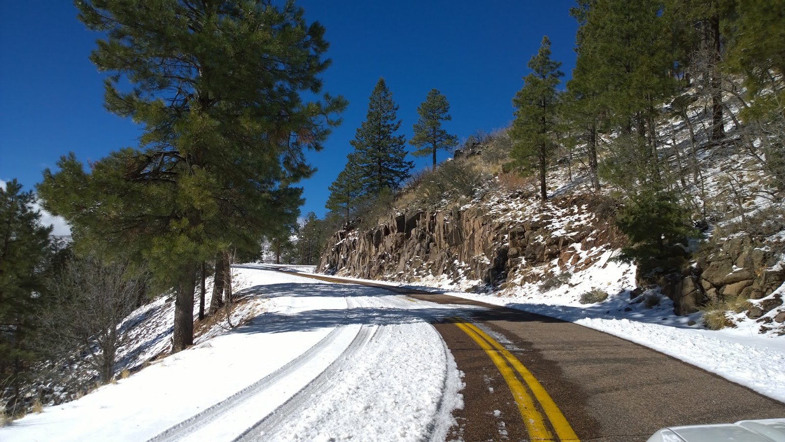
Intermittently, the road had snow on the edges, but it was thin and more like frost, so it wasn’t slippery at all (at the southern end of the route). Of course, you had to think it might get slippery at any point, so the driving was cautiously slow. I drove most of the route at about 25 mph, right down the center stripe to avoid the more-icy edges, but even that was too fast at some points; some of the hairpin turns are no quicker than 5 or 10 mph even when dry - and there are approximately 400 of them.
Intermittently, the road had snow on the edges, but it was thin and more like frost, so it wasn’t slippery at all (at the southern end of the route). Of course, you had to think it might get slippery at any point, so the driving was cautiously slow. I drove most of the route at about 25 mph, right down the center stripe to avoid the more-icy edges, but even that was too fast at some points; some of the hairpin turns are no quicker than 5 or 10 mph even when dry - and there are approximately 400 of them.
 |
| Mountains in the clouds |
By
the time I reached the top, the air temperature had dropped to between 29 and
35 degrees (in different places). The
sky was partly to mostly cloudy, but there was a lot of sunshine too (depending on where I was at the time). As I reached the highest points, the clouds
were right down on the mountainsides. Eventually, the road became snow packed, but
it was still mostly thin (no more than three or four inches) and while I
encountered a little bit of ice occasionally, for the most part the road
surface was easily drive-able. Had I known the condition of the road before attempting it, I probably would not have gone this way. I made it OK, but I wouldn't have taken the risk on such a road if I had known about it. I could just as easily have driven the US180 valley route across the border in New Mexico. It's pretty too.
I worried the entire distance that it would become impassable and I would have to go back, but that didn’t happen. The risky part is that the drop-offs on the roadsides are very steeply hundreds, even thousands of feet in some cases – and there are no guard rails. I tried not to think about that and kept my driving slow and smooth, smooth, smooth. Remember, this is nothing to complain about, I took this route deliberately. I’d never driven it in winter before – wasn’t even sure I could.
I worried the entire distance that it would become impassable and I would have to go back, but that didn’t happen. The risky part is that the drop-offs on the roadsides are very steeply hundreds, even thousands of feet in some cases – and there are no guard rails. I tried not to think about that and kept my driving slow and smooth, smooth, smooth. Remember, this is nothing to complain about, I took this route deliberately. I’d never driven it in winter before – wasn’t even sure I could.
 |
| 9,300 feet msl |
I
only saw two critters along the way – both birds. First, I couldn’t believe I saw a blue-jay
fluttering in the trees beside the highway.
You cannot mistake a Jay – they are very distinctive. So my question is, don’t they fly south for
the winter? Crazy bird! Then, much farther north, between Hannagan
Meadow and Alpine, I think I saw an eagle – a big eagle. I say I think, because I didn’t get a good
look at it (it was launching from the ground into flight and I mostly saw it
with my peripheral vision) and it could have been a buzzard. But it was a large bird and I choose to
believe it was an eagle. It was too big
to be a hawk.
 |
| Red Mountain Lookout |
 |
| Little bit of snow... |
 |
| Little white truck |
Continuing on past Hannagan Meadow (which was open, but I didn't stop), the road descends slightly from Beaverhead into Alpine. I don’t think Beaverhead is anything more than a junction – I didn’t even note it as I passed by. There isn’t much of a descent either, this is all high country. In the summer, it is a desert-dwellers paradise -- “they” (the locals) call us “flat-landers.” Everyone in the two hot metro areas goes up there to camp, fish, hike, hunt, etc. in the cool mountain air. Hannagan Meadow was built in 1926 and has operated continuously year-around since then. This highway was dedicated there (you can still see the memorial plaque). The lodge has rooms and cabins and the rates are reasonable - it was one of my mother's favorite places in Arizona.
 |
| Alpine |
 |
| Escudilla Mtn |
From
Show Low, it was all about getting home.
I was undecided about route – my choices were US60 down to Globe and on into
Phoenix on that highway, or (2) SR260 across the Mogollon Rim to Payson and
south to Scottsdale on SR87, or even a third alternative, SR260 to Payson, then
north on SR87 and across to Camp Verde, then down to Phoenix on I-17. The last would have been my choice except it
would have taken an extra hour – so I chose SR87 from Payson to Phoenix.
From
Show Low to Payson on SR260, you’re running on top of the Mogollon Rim for a
good part of the way, then it drops off and down from the Rim between Forest
Lakes and Christopher Creek. The first
part is through scrubby terrain and forest-fire-damaged areas, but eventually
you are in what's left of Arizona’s old growth Ponderosa pine forest.
It’s a pretty drive, and some of it has been divided. From
Payson south, while not interstate, the road is super-highway, down through
Rye and the Tonto Basin, past Mt Ord and Sunflower, and finally Four Peaks and the Superstition
Mtns off to the left as you cover the last miles toward Fountain Hills or Mesa. As I passed Rye, in the beautiful Tonto Basin with all it's old west and Zane Grey history, I thought it to be my ultimate goal in life to own an old-time western saloon there, complete with a rag-time piano-player! Alas, I will never realize that particular dream.
 |
| Mt Ord, Reno Pass & SR87 |
South
of Mt Ord and Sunflower, the terrain becomes predominantly piles of large
boulders. I was once told by a geology
professor at Scottsdale Community College that those boulders had been the top
of a mountain once – the mountain we now call Four Peaks exploded like Mt St
Helens at one pre-historic time – and scattered its top all over present-day Gila County. The Apaches’ name for Four Peaks was “Mazatzal,”
(or something phonetically similar) which translates as “the spaces between,” referring to the
gaps between the four peaks.
 |
| Weaver's Needle |
 |
| Verde River |
From
SR87 at Fountain Hills, I took the Shea Blvd “cut-off” across the McDowell Mtns
into North Scottsdale, and home. My
route covered right about 555 miles in a loop – much of it at very low
speeds. It took about a day and a half,
all together.
Keep the shiny side up (and between the fenceposts)!
Bob
Keep the shiny side up (and between the fenceposts)!
Bob